![]() The Moon Valley is named for a star child who was kidnapped by sea-beings, escaped, and swam up the river to settle, after having been transformed into the Moon. The child's name was Si. Mount Si is the mountain of the moon.
The Moon Valley is named for a star child who was kidnapped by sea-beings, escaped, and swam up the river to settle, after having been transformed into the Moon. The child's name was Si. Mount Si is the mountain of the moon.
The description of this hike is from 1996.
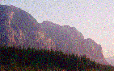
![]() The Moon Wall hike is seldom seen by most folk. I refer to it colloquially as the "back side of Mt. Si." It is a stunning escarpment of cliffs down which cascade tiny streams with intricate and beautiful waterfalls. It is very inaccesible and is a dangerous place to hike. Be forewarned. If you go there, be prepared. Know what you are doing. Take the ten essentials. Go in a party of four, so that two people can go for help and one can stay behind if someone gets hurt. Be prepared to bushwhack, get wet, get covered with spiderwebs and get dirty. There are far greater spectacles on far easier trails. It is probably better to follow them.
The Moon Wall hike is seldom seen by most folk. I refer to it colloquially as the "back side of Mt. Si." It is a stunning escarpment of cliffs down which cascade tiny streams with intricate and beautiful waterfalls. It is very inaccesible and is a dangerous place to hike. Be forewarned. If you go there, be prepared. Know what you are doing. Take the ten essentials. Go in a party of four, so that two people can go for help and one can stay behind if someone gets hurt. Be prepared to bushwhack, get wet, get covered with spiderwebs and get dirty. There are far greater spectacles on far easier trails. It is probably better to follow them.
![]() There is one other "attraction" to this hike. I have never seen more terrible and dramatic evidence of the tragedy of clear cutting. These beautiful streams have all been blown out due to the clearcutting on the top of Mt. Si, miles away and invisible from the trail. Just a few years ago, Harvey Manning described Crater Creek in the following terms: "The bouldery, brawling cataracts of Crater Creek will be a famous place to get out the sardine sandwhiches and turn the kids loose to wade." Now it's just a huge washout, of interest only as an ecological tragedy. It will be centuries before these streams recover, and then, only if they are left alone.
There is one other "attraction" to this hike. I have never seen more terrible and dramatic evidence of the tragedy of clear cutting. These beautiful streams have all been blown out due to the clearcutting on the top of Mt. Si, miles away and invisible from the trail. Just a few years ago, Harvey Manning described Crater Creek in the following terms: "The bouldery, brawling cataracts of Crater Creek will be a famous place to get out the sardine sandwhiches and turn the kids loose to wade." Now it's just a huge washout, of interest only as an ecological tragedy. It will be centuries before these streams recover, and then, only if they are left alone.
![]() There is a description of the Moon Wall hike in Harvey Manning's book "Hiking the Mountains to Sound." There was legal action following publication of the book, and the page on the book is stamped "Closed to Public Access." The Mountaineers (the publishers) got burned badly and no longer provide information about this hike. In short, I am told that the route that is described to get around private property to get to the hike is inaccurate due to either faulty surveys or faulty maps and that there was some failure by the DNR to keep things properly updated.
There is a description of the Moon Wall hike in Harvey Manning's book "Hiking the Mountains to Sound." There was legal action following publication of the book, and the page on the book is stamped "Closed to Public Access." The Mountaineers (the publishers) got burned badly and no longer provide information about this hike. In short, I am told that the route that is described to get around private property to get to the hike is inaccurate due to either faulty surveys or faulty maps and that there was some failure by the DNR to keep things properly updated.
![]() Therefore the easy way to get to this hike is closed. It passes over private property. Do not go this way. Instead you will need to use logging roads to get to the end of the trail. The idea is to hike it backwards, from top to bottom, and then to turn around and go back to the top to avoid crossing the private property.
Therefore the easy way to get to this hike is closed. It passes over private property. Do not go this way. Instead you will need to use logging roads to get to the end of the trail. The idea is to hike it backwards, from top to bottom, and then to turn around and go back to the top to avoid crossing the private property.
![]() Head north from North Bend on Ballarat Avenue. Ballarat will become 428 Ave SE. Cross the North Fork of the Snoqualmie River. 428 SE becomes SE North Fork Road. Two miles after crossing the river, you will come to a fork in the road. Both forks are labelled "Dead End." The one on the left says its 24 miles to the dead end. The other one (the wrong one) goes to Ernie's Grove. Take the left fork. Drive 4 miles to Gate 10. Weyerhauser usually has someone on duty. Say hello nicely and maybe they will give you a map. Park. Get out your moutain bikes. If you start early enough in the day, you can do this without mountain bikes, but I don't recommend it. You are now at 970 ft of elevation and raring to go.
Head north from North Bend on Ballarat Avenue. Ballarat will become 428 Ave SE. Cross the North Fork of the Snoqualmie River. 428 SE becomes SE North Fork Road. Two miles after crossing the river, you will come to a fork in the road. Both forks are labelled "Dead End." The one on the left says its 24 miles to the dead end. The other one (the wrong one) goes to Ernie's Grove. Take the left fork. Drive 4 miles to Gate 10. Weyerhauser usually has someone on duty. Say hello nicely and maybe they will give you a map. Park. Get out your moutain bikes. If you start early enough in the day, you can do this without mountain bikes, but I don't recommend it. You are now at 970 ft of elevation and raring to go.
![]() Head due east past the Spur 10 Gate. If you open the gate, be sure to close it behind you. After 1.3 miles cross the North Fork of the Snoqualmie over a small bridge that you might consider jumping off of on your way back to cool down. The bridge is at 1040 ft. Immediately you arrive at a 3 way fork. Take the rightmost. Cross Hancock Creek (signed).
Head due east past the Spur 10 Gate. If you open the gate, be sure to close it behind you. After 1.3 miles cross the North Fork of the Snoqualmie over a small bridge that you might consider jumping off of on your way back to cool down. The bridge is at 1040 ft. Immediately you arrive at a 3 way fork. Take the rightmost. Cross Hancock Creek (signed).
![]() To your right road 32970 leads away to a mystical clearing. Do not take it except as a side trip. Bushwacking from the mystical clearing leads to some lovely views of the North Fork. At 1080 ft elevation there is a fork in the road. Road 32950 (gated), the right fork, leads to a small hydro plant. Do not take this road except as a side trip. Harvey Manning suggests that the Moon Wall jeep trail can be reached by bushwhacking from the Hydro Plant. Do not believe him. It took us an entire day and was one of the least enjoyable and life-risking bushwhacks we have ever done. So, take the left fork (road 4202) banking strongly uphill. At elevation 1240 ft cross a creek. At 1470 ft see another creek with a small waterfall. At 1520 ft see another creek with a nifty waterfall. There is a picture of the nifty waterfall on p. 103 of "Hiking the Mountains to Sound" labelled "Rachor Falls." This is not Rachor Falls but is a small falls on the creek running out of SMC lake. The photographer can be easily forgiven for missing Rachor Falls, as it is nearly impossible to get to (but see below). At 1690 ft road 32910 heads off as a spur to intersect the hydro vista at the halfway point. Harvey Manning also suggests this as a alternate route to the jeep trail. Forget it. Crossing Rachor Creek is impractical here. At 1690 ft reach the top of the Hydro vista. There is a great view here. Again at 2100 ft there is another great view. This is Rachor Vista.
To your right road 32970 leads away to a mystical clearing. Do not take it except as a side trip. Bushwacking from the mystical clearing leads to some lovely views of the North Fork. At 1080 ft elevation there is a fork in the road. Road 32950 (gated), the right fork, leads to a small hydro plant. Do not take this road except as a side trip. Harvey Manning suggests that the Moon Wall jeep trail can be reached by bushwhacking from the Hydro Plant. Do not believe him. It took us an entire day and was one of the least enjoyable and life-risking bushwhacks we have ever done. So, take the left fork (road 4202) banking strongly uphill. At elevation 1240 ft cross a creek. At 1470 ft see another creek with a small waterfall. At 1520 ft see another creek with a nifty waterfall. There is a picture of the nifty waterfall on p. 103 of "Hiking the Mountains to Sound" labelled "Rachor Falls." This is not Rachor Falls but is a small falls on the creek running out of SMC lake. The photographer can be easily forgiven for missing Rachor Falls, as it is nearly impossible to get to (but see below). At 1690 ft road 32910 heads off as a spur to intersect the hydro vista at the halfway point. Harvey Manning also suggests this as a alternate route to the jeep trail. Forget it. Crossing Rachor Creek is impractical here. At 1690 ft reach the top of the Hydro vista. There is a great view here. Again at 2100 ft there is another great view. This is Rachor Vista.
![]() Continue on to 2270 ft. There is an unmistakeable pillbox with a big metal "candy cane" air vent here. Ditch the bikes and get ready for some real fun. Head due west which is straight down a steep scree slope (call this 110 degrees or WSW for purists). At 1990 ft, if you are still alive, cross Rachor Creek as well as you can. If you reach the creek at the same point we did, there are some big old growth logs left from logging that form a small waterfall and can be scrambled across, but be careful as they may be slippery. Incidentally, if it has been raining recently, you are probably muddy after coming down the scree slope, and this is just a taste of things to come, so you may not want to do this hike after a rain. Go straight up the other bank of Rachor Creek. About 20-30 ft from the Creek is the jeep trail. Use your imagination to verify that you are indeed on the jeep trail. It is very easy to miss. Look up at the skyline. Look to your right and left. You are on an amazingly overgrown road. If you are standing on a rockslide, walk parallel to the creek and the road should become apparent.
Continue on to 2270 ft. There is an unmistakeable pillbox with a big metal "candy cane" air vent here. Ditch the bikes and get ready for some real fun. Head due west which is straight down a steep scree slope (call this 110 degrees or WSW for purists). At 1990 ft, if you are still alive, cross Rachor Creek as well as you can. If you reach the creek at the same point we did, there are some big old growth logs left from logging that form a small waterfall and can be scrambled across, but be careful as they may be slippery. Incidentally, if it has been raining recently, you are probably muddy after coming down the scree slope, and this is just a taste of things to come, so you may not want to do this hike after a rain. Go straight up the other bank of Rachor Creek. About 20-30 ft from the Creek is the jeep trail. Use your imagination to verify that you are indeed on the jeep trail. It is very easy to miss. Look up at the skyline. Look to your right and left. You are on an amazingly overgrown road. If you are standing on a rockslide, walk parallel to the creek and the road should become apparent.
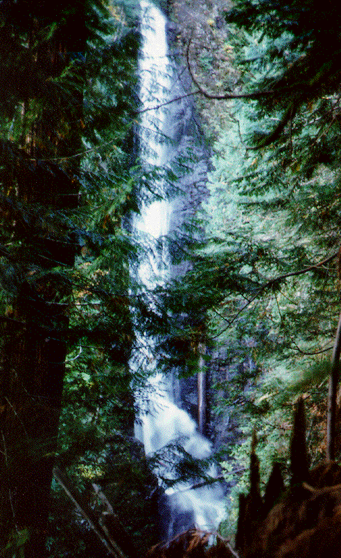
![]() Turn right and head downstream. The trail bends away from Rachor Creek and begins to hug the Moon Wall. After you walk a little ways, if you really want to see Rachor Falls, head straight down the slope next to Rachor Creek at a safe distance form the Creek. The Falls is about 1000 ft below the jeep trail. This is a tough scramble. I hope you are in good shape before doing this. Be very careful. The Rachor Creek Chasm is deep and severe and the slopes can give way. Exercise caution. Our picture of Rachor Falls was taken from this spot. In any case, continuing along the jeep trail you will arrive at 1650 ft of elevation at the first of several washouts. The trail will start to get better, probably as a result of animals using it. Humans do not come here often.
Turn right and head downstream. The trail bends away from Rachor Creek and begins to hug the Moon Wall. After you walk a little ways, if you really want to see Rachor Falls, head straight down the slope next to Rachor Creek at a safe distance form the Creek. The Falls is about 1000 ft below the jeep trail. This is a tough scramble. I hope you are in good shape before doing this. Be very careful. The Rachor Creek Chasm is deep and severe and the slopes can give way. Exercise caution. Our picture of Rachor Falls was taken from this spot. In any case, continuing along the jeep trail you will arrive at 1650 ft of elevation at the first of several washouts. The trail will start to get better, probably as a result of animals using it. Humans do not come here often.
![]() Just above 1000 ft reach an exceptionally large washout. This is Crater Creek. If you were to scramble straight up the washout, you might eventually see something cool. We didn't do this. If you were to continue straight ahead through a huge patch of briars you would reach the private property on which you may not trespass. So turn around here, if not before. Consider scrambling up some of the other washouts for views of beautiful tinkling waterfalls that look like they belong in Japanese gardens.
Just above 1000 ft reach an exceptionally large washout. This is Crater Creek. If you were to scramble straight up the washout, you might eventually see something cool. We didn't do this. If you were to continue straight ahead through a huge patch of briars you would reach the private property on which you may not trespass. So turn around here, if not before. Consider scrambling up some of the other washouts for views of beautiful tinkling waterfalls that look like they belong in Japanese gardens.
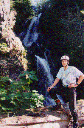
![]() You should probably allocate at least 8 hours for this trip. Make sure you turn around early enough to get back to the Spur 10 Gate well before dark.
You should probably allocate at least 8 hours for this trip. Make sure you turn around early enough to get back to the Spur 10 Gate well before dark.